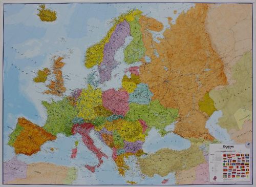
Laminated flat map of Europe in the scale 1:4.3 mill. Size: Width 165 cm x hight 120 cm.
Our politically coloured wall map of Europe features countries marked in different colours, with international boundaries shown. All major towns and cities of Europe are featured within our map, and the countries capital cities are clearly marked. The map contains hill and sea shading adding to the vibrant overall effect. The wall map also contains a section showing the different flags of countries in Europe.
This Large Europe Wall Map Political (Laminated) with encapsulation gives the map a write on / wipe off finish. Using a dry wipe marker, any writing on the map can be wiped off with a proprietary cleaner.
Relaterede varer
-

-

-

-

-
Tilbud!prisvogter
We All Have Our Secrets
Original price was: 85,95 kr..68,76 kr.Current price is: 68,76 kr.. Tilføj til kurv


Relaterede varer
-
Tilbud!prisvogter
The President’s Daughter
Original price was: 85,95 kr..68,76 kr.Current price is: 68,76 kr.. Tilføj til kurv -
Tilbud!prisvogter
Tour de Force
Original price was: 124,95 kr..99,96 kr.Current price is: 99,96 kr.. Tilføj til kurv -
-
-
Tilbud!prisvogter
We All Have Our Secrets
Original price was: 85,95 kr..68,76 kr.Current price is: 68,76 kr.. Tilføj til kurv


